
MapDash™ for Real Estate: A One-Stop-Shop for CRE Location Intelligence
“Location, location, location” is a common phrase in the real estate industry. The one element you cannot change about a property is where it is, so selecting the right place is critical when making an investment. However, this is easier said than done. Choosing the right location in real estate requires detailed analysis of a site’s characteristics, including both the property itself and the surrounding area.
In residential real estate, homebuyers often cultivate a localized knowledge of the area they are looking to invest in from family, friends, and experience. By contrast, commercial real estate (CRE) developers, brokers, and investors typically analyze numerous sites across a large geographic area, calculating risks and opportunities accurately to make informed decisions. In such a competitive and complex market, CRE firms cannot rely on anecdotes, but instead require reliable data for analysis. Layering datasets helps CRE companies get a well-rounded, realistic view of a property and its surroundings, generating location intelligence that gives their firm a competitive edge while maximizing their ROI.
Despite this need for detailed data analysis, many CRE professionals do not leverage location intelligence in their current workflows. Traditional solutions require extensive data sourcing, cleaning, and manipulation among a disparate suite of tools. At Datastory, we specialize in helping CRE firms harness the power of location intelligence for data-driven decision-making in one convenient location, without the heavy data science lift typically needed for in-depth insights.
Location intelligence data layers for CRE
Developing location intelligence for CRE decision-making involves layering multiple datasets together to create a holistic view of a property and its surroundings. Essentially, CRE professionals must leverage data to gain the highly detailed, nuanced knowledge typically only possessed by locals familiar with the area. In many cases, CRE firms analyze locations across large regions or even the entire country, making site visits unfeasible without first narrowing down the list of suitable properties. This filtering is where location intelligence comes in.
CRE decision-making requires deep location intelligence about the surrounding geography, demographics, consumer behavior, and more.
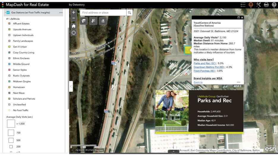
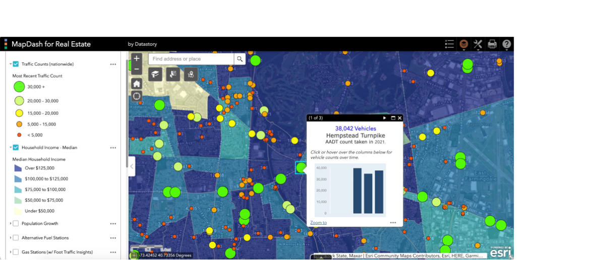
Various characteristics factor into a CRE firm’s decision to invest in or sell a property, ranging from local traffic conditions to parcel characteristics and demographic profiles of nearby neighborhoods. CRE site selection is powered by analyzing these factors together to deduce the best possible property for a particular need. Common data layers used in CRE property analysis and site selection include:
Parcel boundaries
Property attributes (environmental and policy)
Local demographics
Lifestyle segmentation
Consumer behavior
Transportation networks
Points of interest (POIs)
Street view imagery
and more
These datasets are traditionally produced by different organizations, making it time consuming for CRE firms to source and ingest into their analytics environments. Many of these datasets require manipulation by geographic information systems (GIS) specialists and data scientists before real estate decision-makers can effectively analyze them, further contributing to a barrier to entry for location intelligence in the industry.
Out-of-the-box location intelligence for CRE professionals
MapDash is preconfigured with all of the data layers CRE professionals need to analyze locations and make site selection decisions.
To alleviate the technical and timeline challenges in cultivating location intelligence in CRE, Datastory has developed MapDash for Real Estate. Preconfigured with the location-based data layers real estate professionals use most in an intuitive user interface, MapDash for Real Estate enables investors, brokers, and developers to do what they do best - make smart investment decisions. With MapDash, CRE firms ranging in size from independent shops to large corporations can make informed decisions based on location intelligence, but without the data science and geospatial configuration work required by traditional solutions.
MapDash for Real Estate can be customized for specific organizational needs. For example a multi-family edition is available, preconfigured with the data layers specific to developing properties with multiple housing units. Similarly, MapDash for Real Estate can be configured to include curated data that aligns with state Qualified Action Plans used by firms who are competing for low income housing tax credit (LIHTC) projects, which are highly competitive and have their own data input requirements.
To show what preconfigured location intelligence data for CRE looks like in action, check out this site selection workflow walkthrough.